4.9 Google
ESA figure sets · Groundwater & LUST figures · GIS mapping — drafted for environmental consultants, on your title block
Email us the site address, your project number, and your logo for the title block — plus the report data: sample locations, well elevations, aerials, hand sketches, or GPS coordinates. We work from whatever you have. You get a fixed cost-and-time estimate for approval before any drafting starts.
Our CADD professionals build your figure set in AutoCAD and ArcGIS Pro — site, area, detail, and exceedance maps; potentiometric and groundwater flow maps; cross-sections; LUST figures — on your title block. Most figure sets turn around in 1–4 days. We work white-label; your client never sees us.
On completion you receive press-ready PDF figures for your report plus the native AutoCAD DWG files and associated external references — the work is yours to edit and reuse. Need a revision? Send the markup and we turn it around fast.
"We were running up against some deadlines, and they jumped through hoops to get everything completed on time."
"The A3E team did a great job on our Phase 1 report. They were quick, thorough and professional."
"They were able to give me all of the information that I needed. Highly recommend A3 Environmental."
DWG files delivered
Small business (WOSB)
Environmental consulting
Google Reviews
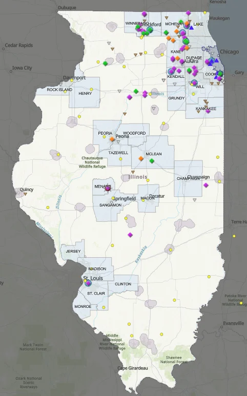
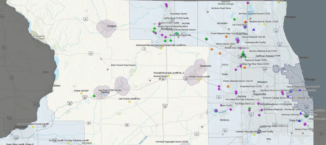
Click on the image for an interactive map. This is a good example of one of our many GIS projects. In this map we were tasked by the Illinois Department of Transportation (IDOT) to provide an evergreen representation of where all the CCDD facilities are in the state. We’ve been “Keeper of the Map” since 2022.
Environmental drafting is the art of turning the data in your environmental reports into clean, professional figures. A3 Environmental’s CADD/GIS department produces those figures for other environmental consulting firms — as overflow capacity when your workload spikes, or as your standing production team when you don’t carry a drafter on staff. Don’t have a trained CADD professional? Is your drafter out sick or on vacation? Has the work grown past your in-house capacity? We pick up the figures so you can stay focused on the assessment.
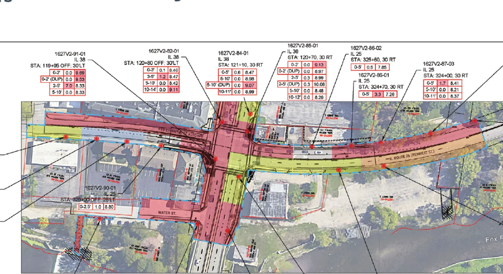
We produce the full range of environmental report figures: Phase I, II, and III ESA figure sets — site topographic maps, area maps, detail maps, and analytical/exceedance location maps with detailed call-outs — plus potentiometric contour maps and groundwater flow analysis, geotechnical cross-sections, 45-day LUST figure sets for underground storage tank removals, UST detail maps, asbestos abatement drawings, soil management plan figures, historical feature overlays, asphalt area calculations, and conversion of paper files to editable electronic CAD. A potentiometric or groundwater flow map needs a minimum of three monitoring well elevations to calculate the hydraulic gradient.
| Deliverable | Turnaround |
|---|---|
| Phase I ESA figure set | 1–2 days |
| Phase II ESA figure set | 2–4 days |
| Phase III ESA figures | Per project |
| Geotechnical cross-section | 3–4 days |
| 45-day LUST figure set | 3–4 days |
| Historical feature overlay | 1–2 days |
| Asphalt area calculation | Same day |
Regardless of any pricing or turnaround shown on this page, A3 Environmental provides a cost and time estimate for each project that requires your approval prior to commencement.
We draft in AutoCAD (current versions), ArcGIS Pro, Adobe Acrobat DC Pro, and SketchUp, working on your company’s title block so the deliverables look like yours. On completion you receive press-ready PDF figures for your report along with the native AutoCAD DWG files and associated external references — the work is yours to edit and reuse, with no lock-in. To start a figure set we need the site address, your project number, and your logo; for Phase II and III we also need sample location data and any prior ESAs. Well information can come as marked-up aerials, hand sketches, or GPS coordinates.
This is production work done quietly behind your firm’s name — your client never sees us, and you stay the consultant of record. Because the work runs on the files you send rather than a field visit, A3 Environmental drafts for environmental consultants nationwide. Backed by a 4.9★ Google rating and 5,000+ environmental reports of in-house experience, we know what a defensible figure has to show because we write the reports too.